
Boating across Australia’s rivers, coastal waters, and offshore environments requires accurate navigation tools. Unlike driving on land, waterways do not have clear road signs or marked paths guiding vessels from one destination to another. Because of this, reliable navigation systems have become essential for both recreational and experienced boaters.
Modern GPS technology has dramatically improved how boaters navigate and plan trips. Instead of relying solely on paper charts or visual landmarks, today’s boaters can use digital tools that display their exact position, route, and surrounding conditions in real time.
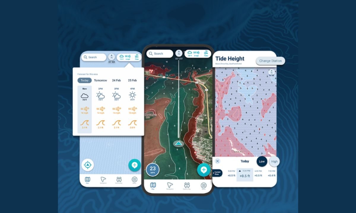
For boaters exploring Australian waterways, tools that function as a boat GPS Australia provide a practical way to combine satellite positioning, digital charts, and navigation planning into a single tool designed specifically for marine environments.
What a marine GPS does
A marine GPS is a satellite-based navigation system that calculates a vessel’s position using signals from multiple satellites. This allows the system to determine the boat’s location, speed, and direction with high accuracy.
Modern marine GPS systems can usually locate a vessel within a few meters when multiple satellites are available, making them one of the most reliable navigation tools on the water.
This level of precision helps boat operators maintain safe routes and avoid hazards even when landmarks are not visible.
Why GPS is important for boating in Australia
Australia has one of the longest coastlines in the world and includes a wide range of waterways such as bays, reefs, rivers, and inland lakes. These environments often present unique navigation challenges.
Tides can significantly change water levels, particularly in coastal regions. Sandbars may shift over time, and shallow areas may not always be visible from the surface. GPS navigation tools help boaters understand where they are relative to these hazards and maintain safe routes.
Accurate navigation is especially important when travelling through unfamiliar areas or during poor visibility conditions.
Combining GPS with digital marine charts
Most modern boat GPS systems display location data on top of digital nautical charts. These charts show important navigation details such as water depth, navigation markers, coastlines, and underwater hazards.
When GPS data is combined with these charts, boaters can clearly see where they are on the water and follow safe navigation routes. Chart-based navigation systems are often referred to as chartplotters because they plot the boat’s position directly on a digital map.
This visual approach makes navigation much easier than interpreting coordinates alone.
Planning trips before leaving the dock
One of the biggest advantages of GPS-based navigation tools is the ability to plan trips ahead of time. Boaters can review charts, create routes, and estimate travel distances before starting their journey.
Trip planning tools allow users to mark waypoints, identify safe channels, and calculate estimated travel times. These features help reduce uncertainty during the trip and allow boaters to focus more on safe operation.
Planning ahead is especially valuable for longer trips or when exploring unfamiliar waters.
Improving safety on the water
GPS technology also plays an important role in boating safety. By continuously monitoring a vessel’s location, GPS navigation tools help boaters avoid shallow areas, reefs, and other hazards.
Many modern systems also integrate additional data such as weather forecasts, tides, and wave conditions. This combination allows boaters to understand how environmental factors may affect their route.
Having this information available in one place helps operators make safer decisions before and during a trip.
Supporting better route efficiency
Another benefit of boat GPS technology is improved efficiency. By identifying the most direct route between two points, GPS navigation tools help reduce unnecessary detours and save fuel.
Accurate route planning also allows boaters to estimate arrival times more effectively. Whether travelling to a marina, fishing spot, or anchorage, knowing how long a journey will take makes trip planning much easier.
Over time, this efficiency can make boating trips smoother and more enjoyable.
GPS tools are becoming more accessible
In the past, marine navigation systems were often expensive and limited to large vessels. Today, GPS navigation technology is available through a wide range of devices, including dedicated chartplotters and mobile navigation apps.
These tools provide powerful navigation features without requiring complex installations or specialized equipment. As technology continues to improve, GPS navigation systems are becoming easier to use and more accessible for everyday boaters.
Navigating with confidence
Reliable navigation is the foundation of safe boating. With accurate GPS positioning, detailed marine charts, and modern planning tools, today’s boaters have access to more information than ever before.
By using modern GPS navigation tools, boaters can explore new destinations, avoid hazards, and plan safer routes across Australia’s diverse waterways.
Ultimately, GPS technology helps transform boating from a challenging navigation task into a more confident and enjoyable experience on the water.